A GIS is: "A system for capturing, storing, checking, integrating, manipulating, analyzing and displaying data which are spatially referenced to the Earth (Chorley, 1987)."
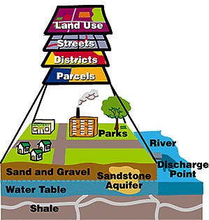
A diagrammatic view of different spatial data layers.
image © ESRI
Note how, like a map, each spatial data theme is referenced to a place on the earth.
How does a computer store coordinate geographic data?
back to What a GIS is NOT ![]()
![]() on to Spatial
Data Types
on to Spatial
Data Types